

Much of the United States’ coastal fire service infrastructure is unprepared for the accelerating effects of climate change. The New York City Fire Department (FDNY), the largest metropolitan fire department in North America, is charged with protecting 8.5 million residents and visitors. As the preponderance of scientific research confirms, rising sea levels and the increasing frequency of severe weather events (SWEs) will directly threaten the department’s ability to maintain uninterrupted emergency service. Events like Superstorm Sandy (2012), Hurricane Ida (2021), and Tropical Storm Ophelia (2023) are no longer anomalies; they are previews. Sandy alone inflicted $19 billion in damage and overwhelmed emergency services across all five boroughs. Since 2012, New York City has endured two major coastal storms and several smaller ones, causing severe localized flooding and revealing critical vulnerabilities in the city’s emergency response infrastructure.

Compounding the threat of coastal inundation, annual precipitation in New York City has increased steadily since records began in 1869. The current scientific consensus holds that 1.5°C of warming by 2050 is a near-certainty, but more recent research suggests that 1.5°C is an optimistic estimate. New York City’s storm sewer systems’ capacity can handle no more than 1.75 inches of rain per hour, and it is already overwhelmed by events that now occur more than once every two years, and the problem is worsening. The FDNY cannot afford to remain reactive to a threat of this magnitude and trajectory.
Methodology
This research applied ArcGIS spatial analysis software and sea level rise (SLR) projections from NOAA’s Fifth National Climate Assessment to overlay the locations of all FDNY firehouses against four inundation scenarios projected for New York City by 2050. Scenarios were modeled at the 10th, 25th, 75th, and 90th percentiles of likelihood, corresponding to 0.3, 0.7, 1.3, and 2.0 feet of SLR, respectively. A four-minute drive-time analysis, consistent with NFPA 1710’s standard for first apparatus arrival, was then applied to determine how many neighborhoods would remain unreachable within the benchmark if their serving firehouse were incapacitated by flooding.
Key Findings
The modeling results are unambiguous. Even under the most optimistic scenario, the FDNY faces a significant reduction in operational coverage. The following table summarizes firehouse inundation across all four scenarios:
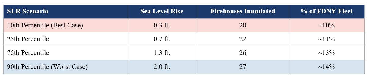
The consequences of inundated firehouses extend well beyond the immediate service area. Units from distant firehouses would be dispatched to fill coverage gaps, cascading response time deficits across the city. Access to critical infrastructure, such as hospitals, emergency shelters, subway tunnels, and transit stations, would be compromised under all scenarios. The drive-time analysis identified large sections of Brooklyn, Lower Manhattan, and Queens, especially the Rockaways, as areas where populations would be unreachable within the four-minute benchmark during a flood event.
Critical Case: The Rockaways
The Rockaways are a coastal peninsula with 124,185 residents. They would lose all three firehouses under the lowest (10th percentile) SLR scenario. Only two bridges provide access to the peninsula, and both approaches are inundated under this best-case scenario, cutting off both residents and any mutual-aid response from the mainland. The Rockaways represent the FDNY’s single most acute infrastructure vulnerability and the most urgent case for relocation or hardening.
Recommendations
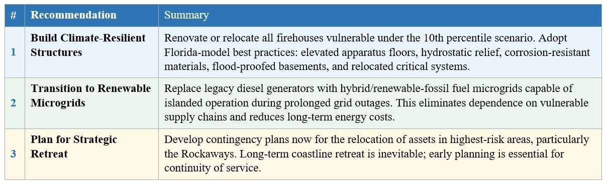
The FDNY stands at a crossroads. The threat is quantifiable, the timeline is known, and the consequences of inaction are unacceptable for a department with a sacred responsibility to the people of New York City. Three strategic recommendations follow from this research:
Conclusion and Broader Implications
This research establishes a clear, data-driven foundation for understanding how climate-driven SLR will erode the FDNY’s operational capacity if proactive steps are not taken. While the modeling used did not account for flood depth or flow dynamics, areas where future AI-driven hydrodynamic modeling will offer greater precision, the findings are conservative by design and represent a floor, not a ceiling, for the department’s risk exposure. The steps outlined in this research are not merely prudent; they are an operational imperative. The FDNY must pivot from a reactive posture to a forward-facing one.
The findings of this thesis are directly transferable to analogous coastal cities, including Boston, Philadelphia, Baltimore, and beyond. Any coastal urban fire department operating aging infrastructure in a floodplain faces a structurally identical problem. The geospatial methodology employed here can be replicated in any municipality with access to NOAA SLR data and GIS tooling. By investing now in adaptive infrastructure, renewable energy, and strategic planning, the FDNY can preserve its mission-critical role in a changing environment and serve as a model for the rest of the urban fire service.