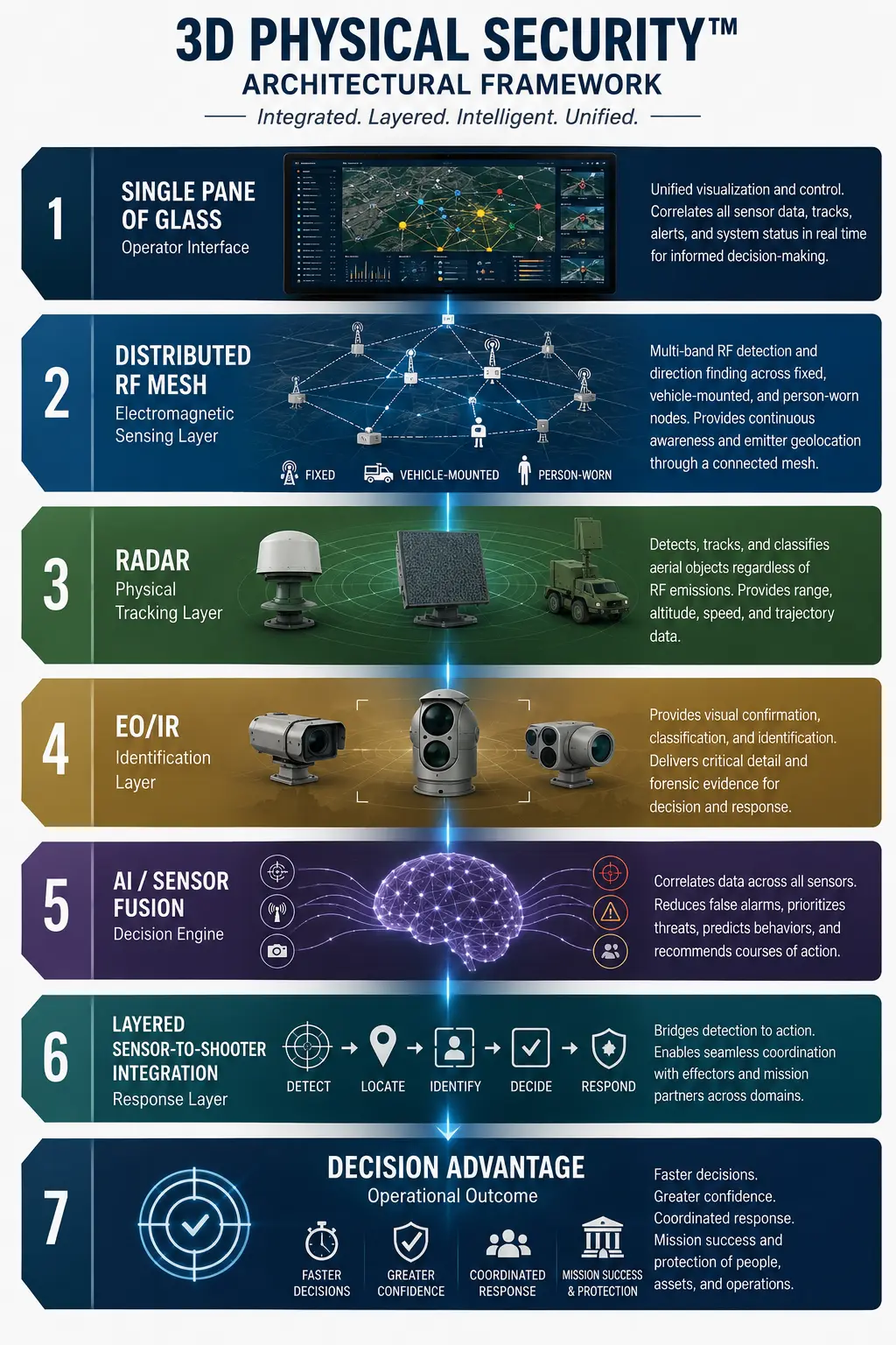

There are three major phases of drone detection and action. First, you must see the drone in time and space; this is tough to do. Secondly, you must have the right tools available to take action; this is layered sensor-to-shooter operations. Thirdly, you must have visualization- a graphic user interface (GUI) that gives you more than symbols on a screen; it must give you understanding.
The security environment is changing faster than many physical security architectures were designed to accommodate. Small unmanned aircraft systems are no longer isolated devices operating over a single predictable control link. They may operate in groups, use different industrial, scientific, and medical spectrum allocations (ISM), shift between command, telemetry, and video links, or fly pre-programmed routes with little or no detectable control signal. In that environment, a system that merely announces that a drone-related signal has been detected may offer only a partial and potentially misleading picture.
The next evolution of counter-unmanned aircraft system capability must integrate detection with direction-finding (DF), persistent multi-band awareness, radar tracking, optical confirmation, and a unified command-and-control environment — a common operating picture. This is not an argument for replacing one sensor with another, but more of an argument for designing a layered system in which every sensor contributes to the same three-dimensional understanding of the operating environment.
Traditional radio frequency (RF) drone detection systems often scan portions of the spectrum in search of recognizable signal characteristics. Once a signal is discovered, the receiver may devote processing resources to identifying, demodulating, or tracking that particular emission. The technical behavior of each product varies, but the architectural concern remains important: a system that concentrates on one frequency or one protocol must not lose awareness of activity elsewhere. A drone environment can contain aircraft operating simultaneously on 433 MHz, 868 or 915 MHz, 2.4 GHz, 5.8 GHz, cellular networks, proprietary links, or analog first-person-view video channels. Awareness of one band does not equal awareness of the airspace, and this is what creates the complexity and the very hard task of detecting a drone effectively. Furthermore, it is imperative that drone detection should be paired with direction finding across multiple relevant bands. Detection answers whether RF activity of interest is present, and direction finding begins to answer where the signal is coming from. When several fixed, vehicle-mounted, temporary, or person-worn nodes observe the same emission at the same time, their bearings, timing, signal characteristics, and positions can be fused to improve geolocation. The result is not simply a warning that a drone may be nearby. It is location intelligence that can help identify the aircraft, the likely control point, the direction of movement, and the relationship between several simultaneous emitters; this helps to create “understanding.”
The distributed model matters because geometry matters. A single sensor can provide useful awareness, but a network of sensors can create intersecting lines of bearing and a much stronger basis for triangulation or multilateration. Fixed nodes provide persistent coverage and known reference points, vehicle-mounted systems extend the protected area and move with a convoy, patrol, or incident response team, and person-worn capability carries sensing into urban canyons, terrain shadows, buildings, temporary event spaces, and other areas where a fixed installation may have limited visibility. Every participating device becomes part of an interlinked RF picture rather than an isolated alarm generator and gives RF detection a boost in a rapidly maturing complex technology environment. Person-worn RF capability is especially important because it changes the geometry dynamically. As security officers, soldiers, law-enforcement personnel, or protection teams move, they create new observation points. Those changing positions can improve confidence, fill coverage gaps, and help distinguish between an aircraft link, a controller, a relay, and unrelated spectrum activity. The intent is not to burden the individual operator with another standalone display. Instead, the intent is for the device to contribute its observations automatically to the larger system while returning only the information that the operator needs for action. This is the foundation of understanding the 90-second decision (Decision Advantage) in a common operating environment.
Additionally, this concept directly supports the framework of 3D Physical Security ™. Physical security has traditionally been organized around separate systems: cameras, access control, intrusion detection, radar, communications, and incident management. Each system may perform well, but the operator is often expected to mentally combine information from several screens under pressure. A true 3D Physical Security architecture treats every sensor as a spatial and temporal contributor to a shared operational model. The important questions are no longer limited to whether something was detected. The system must help determine what was detected, where it is, where it is moving, who or what may be controlling it, which other sensors can confirm it, and what response should follow. This quickly becomes a chaotic challenge.
Now, let’s take this from independent sensors to a distributed RF mesh. The larger opportunity is not simply to add direction-finding capability to an individual RF detector. It is to rethink how RF sensors function as part of a connected operational architecture. In many current deployments, RF nodes largely operate as independent sensors. They may detect, classify, or estimate the direction of a signal, but their observations often remain tied to a single device, a single location, or a separate vendor interface. Even when several sensors are deployed, they may still function more like a collection of individual alarms than a coordinated RF network. The future should be an interlinked RF mesh in which every available node—fixed, vehicle-mounted, temporarily deployed, airborne, or person-worn contributes simultaneously to the detection and geolocation of RF emitters. Each device should understand its own position, maintain awareness across multiple relevant frequency bands, and share its observations with the broader system in real time. Bearings, timing, signal characteristics, confidence levels, and sensor locations should be fused to develop a stronger and more accurate understanding than any single node could produce independently. This architecture becomes especially important when several drones or controllers are active at the same time, which is beginning to show as the norm. Detecting and tracking one signal must not cause the system to lose awareness of other bands, protocols, or emissions elsewhere in the environment. Persistent multi-band awareness should continue while the network collectively develops lines of bearing, correlates related signals, and refines the estimated locations of aircraft, controllers, relays, or other emitters. The design objective is not serial attention, in which the system concentrates on one signal and then searches for the next.
The objective is simultaneous awareness across the RF environment. The value of the mesh also increases as the network changes shape. A fixed sensor provides a stable reference point, while a vehicle-mounted or person-worn node creates new geometry as it moves. Each additional observation point can improve accuracy, reduce uncertainty, fill a coverage gap, or help overcome the effects of terrain, buildings, signal reflections, and limited line of sight. In this model, mobility is not merely a deployment convenience. It becomes part of the geolocation process. This is the architectural shift that deserves greater attention within the counter-UAS market. The industry has developed capable RF detectors, direction-finding systems, radars, cameras, and command-and-control platforms, but the full potential of these technologies will not be realized while they continue to operate as isolated capabilities. A truly distributed RF mesh would turn each deployed device into a contributing member of a larger sensing system while maintaining the continuous multi-band awareness required in a complex drone environment. It would move counter-UAS operations beyond isolated detection and toward persistent, collaborative understanding.
RF direction finding provides the electromagnetic layer of that model. Radar provides the kinematic layer by establishing that an object is physically present in the airspace and by tracking range, bearing, altitude, speed, and trajectory. Electro-optical and infrared systems provide identification and visual confirmation. Access control, perimeter systems, and ground sensors add context about protected areas and human activity. Analytics and command-and-control software correlate the observations, apply policy, prioritize risk, and guide the response. The value comes from the relationship among these layers, not from any single sensor operating alone.
Furthermore, radar is therefore an essential tool in the layered package. RF systems can reveal command links, telemetry, video transmissions, or other emissions, but they cannot be expected to detect an aircraft that is truly RF silent, flying autonomously, or using a communications method outside the receiver’s coverage. Radar provides an independent physical measurement of airspace movement and can continue to track a target even when no useful RF signature is available. Modern electronically scanned radar illustrates how this layer can be deployed in fixed, portable, temporary, airborne, and on-the-move configurations. The radar family is designed to detect, classify, and maintain precision tracks on small airborne objects and to feed those tracks into external command-and-control and sensor-fusion environments. That capability is particularly valuable for RF-silent drones, hovering aircraft, and complex airspace in which optical systems may need accurate cueing. Radar should not be described as the entire counter-UAS solution; it should be recognized as a critical physical-detection and tracking layer within a larger integrated package.
The complementary relationship is straightforward. Radar can establish where an aircraft is and how it is moving, but distributed RF direction finding can help determine where an associated emitter or controller is located, which bands are active, and whether several links are operating at once. Electro-optical and thermal cameras can provide visual identification. Other sensors may add acoustic, perimeter, identity, or environmental context. When these elements are fused, a radar track can cue a camera, an RF bearing can strengthen confidence in a radar classification, and a person-worn node can provide a new angle on an emitter that was difficult to resolve from the fixed perimeter. Direction finding, although not a new concept, needs more attention in the evolving ecosystem.
Now, let’s discuss why and where the Single Pane of Glass becomes operationally meaningful. A single pane should not mean placing several vendor windows on one monitor. It should mean presenting one incident assembled from many validated observations. An operator should see a coherent event in space and time: an aircraft track entering a protected volume, RF activity associated with that track, an estimated controller location, camera imagery, applicable restricted zones, nearby personnel, and recommended response actions. The system should preserve access to the underlying sensor detail while preventing the operator from having to perform the fusion manually. Using advanced AI, this challenge can be solved. It is a meaningful concept to alleviate operator paralysis while creating “understanding” for a decision. In a private-sector setting, this architecture can protect airports, energy facilities, data centers, seaports, correctional institutions, corporate campuses, stadiums, and major public events.
A fixed radar and RF perimeter may provide continuous airspace awareness while mobile and person-worn nodes close temporary gaps, support investigations, and improve localization. The same common operating picture can coordinate security operations, facility leadership, public safety, and law enforcement without forcing each stakeholder to interpret a different technical interface. In military environments, the requirement is even more demanding. Forward operating locations, airfields, maneuver formations, convoys, ports, and critical command nodes may face several drones using different frequencies, flight profiles, and levels of autonomy. A single alert on one band cannot be treated as a complete threat picture. The network must continue to search, detect, classify, locate, and track additional activity while maintaining awareness of the first contact. Fixed and mobile sensors must work together, and person-worn nodes should contribute to the same tactical picture without creating additional cognitive burden for the warfighter.
Current technology demonstrates many parts of this vision, but the market remains fragmented. High-performance radars can produce accurate tracks and integrate with command-and-control systems. RF surveillance platforms can monitor wide frequency ranges, identify known signal patterns, estimate direction, and in some configurations combine multiple sensors to triangulate emitters. Counter-UAS platforms can fuse radar, RF, cameras, and mitigation tools. The remaining gap is often architectural and operational: sustaining simultaneous awareness across multiple relevant RF bands, distributing direction-finding functions across fixed and mobile nodes, and presenting the resulting information as one trusted and usable incident rather than a collection of separate alarms. The design principle should be persistent awareness rather than serial attention. Once one signal is detected, the system must continue looking for others. Once one aircraft is tracked, the system must continue assessing the rest of the airspace. Once one sensor develops a track, every relevant sensor should be able to contribute without creating duplicate incidents. This becomes increasingly important in a swarm, diversion, or coordinated intrusion, where the first detected drone may not be the primary threat.
A resilient architecture must also recognize that sensor performance depends on environment, placement, spectrum congestion, line of sight, terrain, weather, target characteristics, and integration quality. Direction finding can be affected by multipath and reflections. Radar can face clutter and classification challenges. Cameras can be limited by weather, lighting, distance, and obstructions. RF detection can be defeated by autonomy or unfamiliar protocols. Layering is valuable precisely because these limitations are different. One sensor can compensate for another, and agreement among independent sensors raises confidence. The future of counter-UAS is therefore not a contest between RF detection and radar, or between fixed and mobile systems. It is a connected sensing architecture built around complementary capabilities. Multi-band RF awareness reveals activity in the electromagnetic environment. Distributed direction finding turns that activity into location intelligence. Radar establishes and maintains the physical air track. EO/IR provides confirmation. Person-worn and vehicle-mounted nodes extend coverage. Sensor fusion connects the evidence, and the Single Pane of Glass presents the event in a form that supports a timely decision.
This is the logical extension of 3D Physical Security. The protected environment is not only the fence line, the building, or the camera view. It includes the low-altitude airspace and the electromagnetic activity moving through it. Extending direction finding into the RF sensor solution makes sense and supports the complex task of finding a small object flying very fast that is extremely agile and maneuverable. Organizations that connect these dimensions will be better prepared to detect multiple drones, locate associated emitters, maintain awareness across several RF bands, direction find with accuracy, and coordinate a response from one common operational picture. The objective is not more alarms. The objective is a faster and more complete understanding of the threat. In the end, eliminating the fragmentation by adding direction finding to the RF sensor as a norm may be the most prudent step in the CUAS evolution. The next generation of counter-UAS will be defined by who can most effectively connect every sensor, every RF observation, and every physical track into a unified understanding of the operating environment. That is where distributed direction finding, layered sensor integration, the Single Pane of Glass, and 3D Physical Security™ come together to create true decision advantage.